Research Report #52 — Turnpikes and Taverns in the Shawangunks
For many years scientists and naturalists have been studying and observing the flora and fauna of the Shawangunk Ridge. Foremost among them was Daniel Smiley, for whom Mohonk Preserve’s Daniel Smiley Research Center is named. Dan wrote numerous reports summarizing his observations on various topics. This regularly occurring series will feature some of these reports; some hold tremendous scientific value today and just await an interested researcher to follow up, others showcase a quirky sense of humor or highlight an oddity of nature.
Read the Report: Turnpikes and Taverns in the Shawangunks. May 1988. Daniel Smiley and Alice Cross.
A Note from Paul C. Huth, Director of Research Emeritus: Having the privilege of growing up on a farm in Esopus, dating back to at least the 1790s, I learned over the years how most of the physical features that I recognized on the land, and even carried over into many of the farm buildings, were actually “modernizations” or reuse of something that had existed earlier to support a then needed part of the farm operation. These included stone walls, old faint tracks and lanes, farm roads that were once “public” roads, a log cabin cellar hole that predated the old stone farmhouse, and in many places old plow lines from past cultivation. From my perspective today, I like to think of my personal farm experience as “People and the Land through Time,” taken after the title of a 1998 book written by friend and Mohonk Preserve Research Associate Emily W. B. Russell.

In my many years working on research projects with Daniel Smiley at Mohonk, I would often hear him use the term, a “sense of place,” describing a life long familiarity with and closeness to the “home” land. Where ever we go on Mohonk Preserve lands today, we can still see extensive features in the landscape that remain from past human use. We are fortunate that many of these have been well documented over the decades by Dan and Keith Smiley, and staff of The Mohonk Trust and Mohonk Preserve.
In this 1988 Research Report, “Turnpikes and Taverns in the Shawangunks,” Dan and Alice document some of the ways people got around between the ridge communities and farms, how commerce evolved with the need to transport farm produce, the harvest and sale of extensive forest products like tanbark and charcoal, and an increase of manufactured products like barrel hoops, millstones, and cement. As distances and needs increased, “taverns or road houses (were needed) to feed (and house) man and beast.”

Historically, we have good documentation of old roads running on both sides of the ridge, dating to the 17th century, and as “directed by the State Legislature…., routed according to the traffic patterns of people and products.” They still exist, but now remain mostly as local dirt roads or are abandoned, found as tracks through the woods. The important and historic road on the east side of the ridge was in part a drovers route for stock moved “on the hoof,” “from (the) Lake Champlain (area) to New York or Philadelphia.” It was “also known as (the) Albany Post Road.” And, as a stagecoach route, it ran inland from the Wallkill, “to avoid seasonal flooding,” and passed “through Springtown, Canaan, Butterville, and Tuthilltown.” In Butterville, there was an establishment called the drover’s inn. Likewise, the long-distance road on the west side of the ridge was called the Old Mine Road, running just over a hundred miles between “the Hudson River at Kingston to the Delaware River at Port Jervis.” Much of the route in New York State has been overtaken by the modern U.S. Route 209.

Connecting roads were constructed by private turnpike companies “in an attempt to improve local road(s) conditions.” One, “licensed in 1809,” was built from the Hudson River to Ireland Corners in Gardiner, “ending at the Shawangunk Stage Road beyond Tuthilltown.” To reach the Rondout Valley, having to cross over the ridge, the Stage Road ran northeast and joined a road which followed the old Native American footpath through the Trapps Gap, and over the mountain. As substantial a Native American artifact as it was, the footpath was shown on the 1799 map of the Nineteen Partners Tract and labeled “Footpath to Shawangunk.”


About 1830, the New Paltz Turnpike was formally built as a private toll road between the New Paltz Landing on the Hudson River and the village of New Paltz. With the still “urgent need to connect the Rondout Valley with Hudson River tidewater shipping” of all kinds products, including fruit, agricultural produce, and manufactured goods, the shortest route across the ridge from the Rondout Valley to New Paltz was planned and mapped by a group of investors. In 1856, the 23-mile toll road, the Wawarsing & New Paltz Turnpike, was built, at an estimated cost of some $1000 a mile! Even though it was a toll road, with a tollgate located at the top of the Trapps near the location of the present Trapps Bridge over Route 44/55, it apparently lost money from the start “and was sold at a sheriffs sale in 1861.” This historical Turnpike route though, survived and functioned as intended over the decades, “as a natural thoroughfare for the trade and travel” over the mountain, to “materially develop the resources….of the whole country through which it passes.” It certainly changed the world that was the Trapps Mountain Hamlet at the time. Today, considerable modern infrastructure uses parts of the route of this Turnpike, like sections of highways Route 299 and 44/55, as well as local town roads. In some places, it can still be found as an old abandoned woods road. The location of the Mohonk Preserve’s linear West Trapps Entry was built directly over that part of the “dirt-surfaced” Turnpike route. When the new Entry was constructed in 1992/1993, original Turnpike stone culverts were uncovered.

Other roads crossed the ridge to the northeast. A prominent one, built about 1825, with considerable rerouting over the years, passed over at Mountain Rest, essentially connecting New Paltz with High Falls. It is known today as Mountain Rest Road on the east side and Mohonk Road on the west side. Old South Road connected with it at Mountain Rest, coming uphill from Butterville Road, its lower part known today as Pine Road, and its upper part found only as a visible track through the woods. Another once-prominent road crossed the ridge farther northeastward in a gap in the Northeast Boundary Wall cliff, called Clearwater Road, essentially connecting Springtown with High Falls. Today its route is only a track through the woods.

Interconnecting roads running essentially parallel to the slope and joining the cross ridge routes included Mullinex Road on the east slope, connecting Old South Road to Yankee Folly Road and the Wawarsing & New Paltz Turnpike. Nearby, a side road predating the Turnpike, at the present day Jenkins Road, called the “Paltz Point Road,” crossed Yankee Folly Road and went uphill past the Case DuBois Farm and on up the slope to the Garret DuBois Farm established in 1845, and now Mohonk’s Home Farm. It gave access to the lands at the south end of Mohonk Lake under Paltz Point. Mullinex Road today is largely overtaken by the route of the New York Catskill Aqueduct.

Old Creek Road, likely existed in the 18th century, and provided a “southerly pioneer route followed by the (Trapps Mountain) hamlet’s first white settlers moving along the Coxing Kill from its confluence with the Rondout Creek near High Falls.” Its route ran deep in the Coxing Clove, past two mill sites and cellar holes of former dwellings, and is today only an indistinct track through the woods near the flow. Kings Lane, now a yellow-marked Mohonk Preserve trail, takes one upslope from the High Peterskill Trail toward Ronde Barre. It’s route followed, in part, the old Native American Footpath over the ridge. In the 19th century, it provided access to family farms on the ridge summit and continued on towards Rock Hill. Today, most of its summit track is indistinct and difficult to follow.

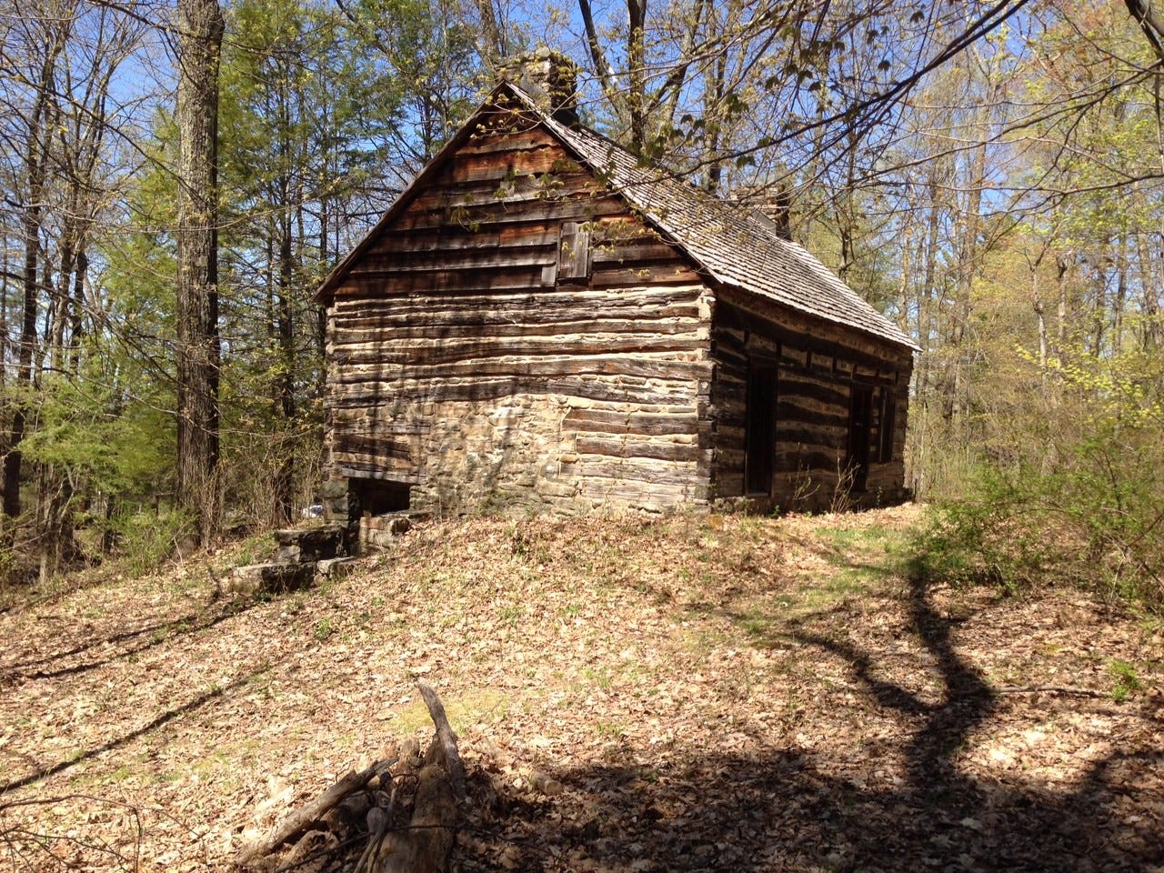
A sharp observant eye on the land today can read these now forested lands and still find cellar holes along these routes indicating one time locations of 19th-century communities, like the Trapps Mountain Hamlet, and individual farmhouses and outbuildings in what was then mostly open cleared land. With these subsistent farms were built the extensive fieldstone walls that we see running for miles through the woods today. This nationally recognized historic landscape allows us to “walk back in time.” Later extensive research by Bob Larsen and Robi Josephson culminated in the 2013 publication of the must-read book, An Unforgiving Land-Hardscrabble Life in the Trapps, a Vanished Shawangunk Mountain Hamlet.

In the day, small family-run hotels and taverns were a regular part of the social structure of road and turnpike travel, each licensed to an individual by the town, “to operate ‘an Inn or Tavern necessary for the benefit of Travellers.’” It was found that essentially “There was at least one public house in each neighborhood.” At the time of this Research Report, some 10 taverns, hotels, and inns were documented locally on the ridge.

Along the Wawarsing & New Paltz Turnpike and the Shawangunk Stage Road, there were three hotels-one run by Isaac Dingee reportedly “the first….in the Trapps,” the Fowler Hotel, “south of the Trapps school, east of the Coxing…,” and the large McGidney’s Hotel, “about 1/4 mile west of the Peterskill.” The site of the Fowler Tavern was the apparent location of a tavern licensed in 1802 to Peter Aldrich, “to operate a public house or tavern ‘near the Clove’”. Along Clove Road, a tavern was once located at the junction of Clove Road and a former public road going up hill towards Rock Hill, called Knob Hill Road. Another early one was located near the junction of Clove Road, and Old Clove Road.

The Stokes Tavern was built by John F. Stokes in 1859 at the north corner of Mohonk Lake, accessible by traveling up the mountain on Stokes Road, or by coming in from Mountain Rest by way of Whitney Road. Stokes Road up the mountain followed one of the first approach routes to Mohonk Lake, in the beginning providing access to the area of Plateau Path for Hemlock tanbark peelers. Dan reported the road “was cleared for use by Mohonk Trail Rides in the 1930’s.” Today it is the route of the red marked Stokes Trail. The Stokes Tavern operated for about 10 years until it became part of the purchase of the 17 acre Mohonk Lake, Paltz Point, and some 300 acres of land by Albert K. Smiley in Mohonk Deed №1, in 1869. An interesting description of the tavern and its operation is presented in this Research Report, taken from the 1911 Partington’s “The Story of Mohonk.”
Not far east from the summit at Mountain Rest, along the south side of Mountain Rest Road, was the location of a tavern called Baranca. The origin of the name is apparently Spanish, and in this Research Report was cited as meaning “cliff”. But modern translation of “barranca” means appropriately “gully”, and it does sit on the edge of a deep gully. Dan later recorded that it was built about 1890 and was apparently operated until the 1920s, and was purchased by Daniel Smiley in 1927. The building was torn down in 1931. Only the foundations remain today on the inside of the road turn.

In lower Mossy Brook, there were two hotels/taverns along 27 Waterbreak Road, now called 27 Knolls Road. One was called the Mossy Brook Hotel, or Tenedini’s, probably dating to the early 20th century, and another called Sparky’s Tavern.

Along Pine Road there was an establishment called Pine’s Saloon, which likely became prominent with the extensive construction of the 126 mile long New York Catskill Aqueduct through the area in 1911 and 1912 by the New York City Board of Water Supply. Major construction of the Aqueduct was complete about 1917. It was said that “contractors admonished local saloons not to sell liquor to the workers.” But Dan believed Pine’s “probably (took) advantage of the patronage of the Degnon contractor’s laborers housed in nearby bunkhouses.” Shortly after the completion of the Aqueduct was the outbreak of World War I. Some 200 soldiers with the New York 10th Militia were brought in to guard the vital New York City water supply. They were reported to be “bivouacked in (likely the same) bunkhouses on Pine Road….located just east of Kleinekill Farm….” The saloon ended business by at least 1925, when the property became part of the Mohonk Estate.
Read the Report: Turnpikes and Taverns in the Shawangunks. May 1988. Daniel Smiley and Alice Cross.